Posts

Showing posts from October, 2019

Verification of tracks made of Lorenzo using GEFS mean fields
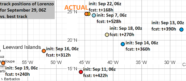
Image
I made eleven tracks of Hurricane Lorenzo. Within 384 hours of cyclogenesis, there were no instances, when I missed cyclogenesis entirely. Peak intensity was surprisingly correct, given how anomalous Lorenzo was. Timing of cyclogenesis was excellent, but dissipation times varied a lot. Position accuracy was good, even outstanding at some lead times. A few tracks erroneously brought Lorenzo to Caribbean or nearby, but they were rare, and such erroneous motion happened at long lead times. As of this analysis, best track positions are available September 21, 06Z thru October 2, 12Z, and as such, position comparisons are possible only for this timespan. Since I give only SSHS categories in my tracks, I don't calculate intensity errors in units of speed, but in categories. For this purpose, I define tropical or subtropical storms as "Category 0", tropical or subtropical depressions as "Category -1" and non-existence of a tropical or subtropical cyclone...

Verification of tracks made of Karen using GEFS mean fields

Image
I made two tracks of Tropical Storm Karen. Additionally, within 384 hours of cyclogenesis, there were eight instances, when I missed cyclogenesis entirely. The two tracks were at short lead times, peak intensity was way too high, too much longevity, and position errors were often also high. As of this analysis, best track positions are available September 19, 18Z thru September 27, 18Z, and as such, position comparisons are possible only for this timespan. Since I give only SSHS categories in my tracks, I don't calculate intensity errors in units of speed, but in categories. For this purpose, I define tropical or subtropical storms as "Category 0", tropical or subtropical depressions as "Category -1" and non-existence of a tropical or subtropical cyclone as "Category -2". In the two tracks, formation times ranged between September 22, 12Z and September 24, 06Z. Average and median was September 23, 09Z. In the ten cases (2 tracks and...

Verification of tracks made of Jerry using GEFS mean fields

Image
I made eight tracks of Hurricane Jerry. Additionally, within 384 hours of cyclogenesis, there were four instances, when I missed cyclogenesis entirely. Peak intensity was typically surprisingly correct, though its timing was not. Errors in speed and longitude of recurving, as well as in initial progression of precursor disturbance, resulted in occasionally huge position errors. As of this analysis, best track positions are available September 14, 18Z thru September 25, 18Z, and as such, position comparisons are possible only for this timespan. Since I give only SSHS categories in my tracks, I don't calculate intensity errors in units of speed, but in categories. For this purpose, I define tropical or subtropical storms as "Category 0", tropical or subtropical depressions as "Category -1" and non-existence of a tropical or subtropical cyclone as "Category -2". In the eight tracks, formation times ranged between September 12, 06Z and ...

Verification of non-detection of Imelda

I made no tracks of Tropical Storm Imelda. Within 384 hours of cyclogenesis, there were ten instances, where I missed cyclogenesis. At the lead time of 1 day ( 24 hours), there were 0 misses. At the lead time of 2 days ( 48 hours), there was 1 miss. At the lead time of 3 days ( 72 hours), there was 1 miss. At the lead time of 4 days ( 96 hours), there was 1 miss. At the lead time of 5 days ( 120 hours), there were 2 misses. At the lead time of 6 days ( 144 hours), there was 1 miss. At the lead time of 7 days ( 168 hours), there was 1 miss. At the lead time of 8 days ( 192 hours), there were 2 misses. At the lead time of 9 days ( 216 hours), there was 1 miss. At the lead time of 10 days ( 240 hours), there was 1 miss. At the lead time of 11 days ( 264 hours), there were 2 misses. At the lead time of 12 days ( 288 hours), there were 2 misses. At the lead time of 13 days ( 312 hours), there was 1 miss. At the lead time of 14 days (...

Verification of non-detection of Humberto

I made no tracks of Hurricane Humberto. Within 384 hours of cyclogenesis, there were ten instances, where I missed cyclogenesis. This situation has the dubious honor of being the first case, when I missed a major hurricane entirely! At the lead time of 1 day ( 24 hours), there was 1 miss. At the lead time of 2 days ( 48 hours), there was 1 miss. At the lead time of 3 days ( 72 hours), there were 2 misses. At the lead time of 4 days ( 96 hours), there were 3 misses. At the lead time of 5 days ( 120 hours), there were 3 misses. At the lead time of 6 days ( 144 hours), there were 4 misses. At the lead time of 7 days ( 168 hours), there were 4 misses. At the lead time of 8 days ( 192 hours), there were 5 misses. At the lead time of 9 days ( 216 hours), there were 4 misses. At the lead time of 10 days ( 240 hours), there were 4 misses. At the lead time of 11 days ( 264 hours), there were 4 misses. At the lead time of 12 days ( 288 hours), th...

Verification of tracks made of Gabrielle using GEFS mean fields

Image
I made six tracks of Tropical Storm Gabrielle. Additionally, within 384 hours of cyclogenesis, there were six instances, when I missed cyclogenesis entirely. Timing of cyclogenesis was close to correct, but dissipation time varied greatly. Peak intensity also varied, though on average, it was pretty accurate. As of this analysis, best track positions are available August 31, 12Z thru September 10, 06Z, and as such, position comparisons are possible only for this timespan. Since I give only SSHS categories in my tracks, I don't calculate intensity errors in units of speed, but in categories. For this purpose, I define tropical or subtropical storms as "Category 0", tropical or subtropical depressions as "Category -1" and non-existence of a tropical or subtropical cyclone as "Category -2".   In the six tracks, formation times ranged between September 2, 00Z and September 5, 06Z. Average was September 3, 02Z and median was Septem...

Verification of tracks made of Fernand using GEFS mean fields

Image
I made four tracks of Tropical Storm Fernand. Additionally, within 384 hours of cyclogenesis, there were nine instances, when I missed cyclogenesis entirely. The few detections were mostly at large lead times. As of this analysis, best track positions are available September 1, 18Z thru September 5, 00Z, and as such, position comparisons are possible only for this timespan. Since I give only SSHS categories in my tracks, I don't calculate intensity errors in units of speed, but in categories. For this purpose, I define tropical or subtropical storms as "Category 0", tropical or subtropical depressions as "Category -1" and non-existence of a tropical or subtropical cyclone as "Category -2". In the four tracks, formation times ranged between August 31, 06Z and September 5, 06Z. Average was September 1, 19Z and median was August 31, 21Z. In the 13 cases (4 tracks and 9 complete misses), peak intensity ranged between Category -2 and Cate...

Verification of tracks made of Erin using GEFS mean fields

Image
I made six tracks of Tropical Storm Erin. Additionally, within 384 hours of cyclogenesis, there were eight instances, when I missed cyclogenesis entirely. It is interesting, that there were more detections and often a higher peak intensity, than with Hurricane Dorian . As of this analysis, best track positions are available August 21, 18Z thru August 29, 06Z, and as such, position comparisons are possible only for this timespan. Since I give only SSHS categories in my tracks, I don't calculate intensity errors in units of speed, but in categories. For this purpose, I define tropical or subtropical storms as "Category 0", tropical or subtropical depressions as "Category -1" and non-existence of a tropical or subtropical cyclone as "Category -2". In the six tracks, formation times ranged between August 26, 12Z and August 29, 12Z. Average was August 28, 06Z and median was August 28, 18Z. In the 14 cases (6 tracks and 8 complete ...

Verification of East Pacific ghost storm tracks of June-July 2019

Image
I falsely detected tropical cyclogenesis in East Pacific (north of the equator and east of 140W longitude) 19 times in June and July of 2019. Tracks were made of five systems. In the calculations, crossover into Atlantic as a tropical cyclone is considered equal to dissipation, and crossover from Atlantic as a tropical cyclone is considered equal to formation or regeneration. Exiting the East Pacific tracking map through its left edge is also considered equal to dissipation. At the lead time of 1 day ( 24 hours), there were 0 false detections. At the lead time of 2 days ( 48 hours), there was 1 false detection. At the lead time of 3 days ( 72 hours), there were 0 false detections. At the lead time of 4 days ( 96 hours), there was 1 false detection. At the lead time of 5 days ( 120 hours), there was 1 false detection. At the lead time of 6 days ( 144 hours), there was 1 false detection. At the lead time of 7 days ( 168 hours), there was 1 fa...