Predictions for 2020-21 - mainly for entertainment purposes
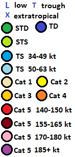
All of the following uses Saffir-Simpson hurricane scale, and 1-min sustained winds. Subtropical cyclones are included in South Atlantic and South-East Pacific, and excluded elsewhere.
Totals for 2020-21 South-West Indian Ocean cyclone season: 10-4-1
Totals for 2020-21 Australian region cyclone season: 10-6-5
Totals for 2020-21 South Pacific cyclone season: 5-2-1
Totals for 2020-21 South-East Pacific cyclone season: 0-0-0
Totals for 2020-21 South Atlantic hurricane season: 2-1-1
Click to expand the image a lot
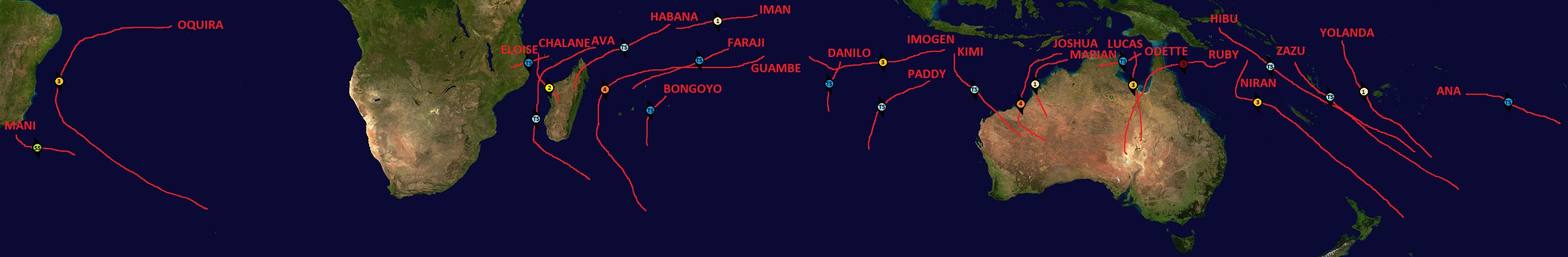
Subtropical Storm MANI forms 90 miles SE of Rio de Janeiro on the 24th. It peaks with 50 mph winds the next day, and dissipates on the 27th.
Tropical Cyclone IMOGEN forms 200 miles SSW of Yogyakarta on the 15th. Moving WSW, it peaks with 115 mph winds on the 19th near Cocos/Keeling Islands. It weakens to Category 1 before crossing to SW Indian Ocean on the 21st, and after turning NW, it dissipates on the 23rd.
Tropical Cyclone YOLANDA forms between Solomon Islands and Tuvalu on the 18th. It reaches peak winds of 90 mph on the 21st, while passing 70 miles west of Nadi. It becomes extratropical on the 24th.
Tropical Cyclone BONGOYO forms 150 miles north of Rodrigues on the 26th. It peaks with 45 mph winds on the 27th, and dissipates on the 29th.
Tropical Cyclone ZAZU forms on the 29th, and hits Efate Island of Vanuatu on the 31st with 50 mph winds.
Tropical Cyclone CHALANE forms near Comoros on the 2nd, and makes landfall at Mecúfi, Mozambique with its peak winds of 45 mph on the next day.
Tropical Cyclone JOSHUA forms in Timor Sea on the 10th. Moving WSW and then SSW while intensifying, it makes landfall 20 miles east of Pardoo on the 14th, with its peak winds of 150 mph.
Tropical Cyclone KIMI forms 200 miles S of Yogyakarta on the 14th. It peaks with 65 mph winds on the 17th, and makes landfall at Gnoorea with 60 mph winds on the 18th.
Tropical Cyclone DANILO forms on the 20th, peaks with 50 mph winds on the 22nd, and dissipates on the 23rd.
Tropical Cyclone ANA forms on the 22nd. Moving east and later ESE, it peaks with 50 mph winds on the 25th, and dissipates on the 28th.
Tropical Cyclone MARIAN forms in Timor Sea on the 10th. It makes landfall at Dampier Peninsula on the 12th, with its peak winds of 80 mph.
Tropical Cyclone NIRAN forms in Coral Sea on the 11th. Moving to WSW, later to ESE, it reaches peak winds of 125 mph on the 15th, as it crosses 160 degrees east. Passing SW of New Caledonia and NE of North Island, New Zealand, it becomes extratropical on the 21st.
Tropical Cyclone ELOISE forms just west of Comoros on the 17th. It reaches peak winds of 100 mph on the 20th, as it makes landfall near Besalampy, Madagascar.
Tropical Cyclone FARAJI forms south of Diego Garcia on the 25th. Moving WSW, it reaches peak winds of 45 mph the next day, and dissipates on the 29th.
The costliest storm of the season is RUBY, with damage amounting to over 100 million USD.
RUBY becomes possibly the strongest cyclone in Australian region.
OQUIRA is the first recorded major hurricane in South Atlantic.
Totals for 2020-21 South-West Indian Ocean cyclone season: 10-4-1
Totals for 2020-21 Australian region cyclone season: 10-6-5
Totals for 2020-21 South Pacific cyclone season: 5-2-1
Totals for 2020-21 South-East Pacific cyclone season: 0-0-0
Totals for 2020-21 South Atlantic hurricane season: 2-1-1
Click to expand the image a lot
December
Tropical Cyclone HIBU forms south of New Britain on the 15th. Moving SE, it peaks with 65 mph winds on the 17th. It weakens slightly to 60 mph before moving between Tarra and Erromango in Vanuatu on the 18th, and becomes extratropical on the 19th.Subtropical Storm MANI forms 90 miles SE of Rio de Janeiro on the 24th. It peaks with 50 mph winds the next day, and dissipates on the 27th.
January
Tropical Cyclone AVA forms 200 miles ENE of northernmost Madagascar on the 2nd. It moves north and west of Madagascar, peaking with 70 mph winds on the 6th. It becomes extratropical on the 9th.Tropical Cyclone IMOGEN forms 200 miles SSW of Yogyakarta on the 15th. Moving WSW, it peaks with 115 mph winds on the 19th near Cocos/Keeling Islands. It weakens to Category 1 before crossing to SW Indian Ocean on the 21st, and after turning NW, it dissipates on the 23rd.
Tropical Cyclone YOLANDA forms between Solomon Islands and Tuvalu on the 18th. It reaches peak winds of 90 mph on the 21st, while passing 70 miles west of Nadi. It becomes extratropical on the 24th.
Tropical Cyclone BONGOYO forms 150 miles north of Rodrigues on the 26th. It peaks with 45 mph winds on the 27th, and dissipates on the 29th.
Tropical Cyclone ZAZU forms on the 29th, and hits Efate Island of Vanuatu on the 31st with 50 mph winds.
February
ZAZU reaches a peak of 60 mph winds on the 1st, and becomes extratropical on the 4th.Tropical Cyclone CHALANE forms near Comoros on the 2nd, and makes landfall at Mecúfi, Mozambique with its peak winds of 45 mph on the next day.
Tropical Cyclone JOSHUA forms in Timor Sea on the 10th. Moving WSW and then SSW while intensifying, it makes landfall 20 miles east of Pardoo on the 14th, with its peak winds of 150 mph.
Tropical Cyclone KIMI forms 200 miles S of Yogyakarta on the 14th. It peaks with 65 mph winds on the 17th, and makes landfall at Gnoorea with 60 mph winds on the 18th.
Tropical Cyclone DANILO forms on the 20th, peaks with 50 mph winds on the 22nd, and dissipates on the 23rd.
Tropical Cyclone ANA forms on the 22nd. Moving east and later ESE, it peaks with 50 mph winds on the 25th, and dissipates on the 28th.
March
Tropical Cyclone LUCAS forms in Gulf of Carpentaria on the 2nd. It achieves peak winds of 125 mph on the 5th, as it makes landfall near Nicholson, Queensland.Tropical Cyclone MARIAN forms in Timor Sea on the 10th. It makes landfall at Dampier Peninsula on the 12th, with its peak winds of 80 mph.
Tropical Cyclone NIRAN forms in Coral Sea on the 11th. Moving to WSW, later to ESE, it reaches peak winds of 125 mph on the 15th, as it crosses 160 degrees east. Passing SW of New Caledonia and NE of North Island, New Zealand, it becomes extratropical on the 21st.
Tropical Cyclone ELOISE forms just west of Comoros on the 17th. It reaches peak winds of 100 mph on the 20th, as it makes landfall near Besalampy, Madagascar.
Tropical Cyclone FARAJI forms south of Diego Garcia on the 25th. Moving WSW, it reaches peak winds of 45 mph the next day, and dissipates on the 29th.
April
Tropical Cyclone GUAMBE forms well southeast of Diego Garcia on the 1st. It peaks with 140 mph winds on the 8th, as it passes between Madagascar and Mascarenes. It becomes extratropical on the 11th.
Tropical Cyclone ODETTE forms in Gulf of Carpentaria on the 5th. The next day, it makes landfall 60 miles south of Nhulunbuy, with its peak winds of 50 mph.
Tropical Cyclone PADDY forms on the 7th, peaks with 70 mph winds on the 10th, and dissipates on the 12th.
Tropical Cyclone RUBY forms in Coral Sea on the 7th. Moving generally westward, it reaches peak winds of 185 mph on the 11th. The next day, it makes landfall near Coen, Queensland with winds of 165 mph. It enters Gulf of Carpentaria as a Cat 1, and on the 14th, it makes landfall near Burketown, Queensland, at secondary peak of 115 mph winds. It continues to move south, and later, the remnant tropical low stalls over Lake Eyre basin for a prolonged period.
Tropical Cyclone HABANA forms on the 24th. It reaches peak winds of 70 mph on the 27th. Weakening slightly to 65 mph, it makes landfall at Vohemar, Madagascar on the 29th.
A tropical depression forms 200 miles NW of Ascension Island on the 27th, strengthening into Tropical Storm OQUIRA the same day. Moving W and WSW, it strengthens to a hurricane.
May
OQUIRA turns to SSW, paralleling the Brazilian coast. It reaches peak winds of 120 mph on the 3rd, while 250 miles ESE of Salvador, Bahia. Turning later to SE, it weakens to below hurricane strength on the 9th, and becomes extratropical on the 10th, while 100 miles NE of Tristan da Cunha.
Tropical Cyclone IMAN forms 320 miles ENE of Diego Garcia on the 20th. Passing north of the island, it reaches a peak strength of 75 mph on the 22nd. Continuing to WSW, it dissipates on the 24th.
CONCLUSION
The deadliest storm of the season is ELOISE, with 20 casualties.The costliest storm of the season is RUBY, with damage amounting to over 100 million USD.
RUBY becomes possibly the strongest cyclone in Australian region.
OQUIRA is the first recorded major hurricane in South Atlantic.

Comments
Post a Comment