Predictions for 2019-20 - mainly for entertainment purposes
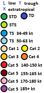
All of the following uses Saffir-Simpson hurricane scale, and 1-min sustained winds.
Totals for 2019-20 South-West Indian Ocean cyclone season: 13-10-8
Totals for 2019-20 Australian region cyclone season: 7-4-0
Totals for 2019-20 South Pacific cyclone season: 5-3-2
Totals for 2019-20 South-East Pacific cyclone season: 1-0-0
Totals for 2019-20 South Atlantic hurricane season: 0-0-0


Totals for 2019-20 South-West Indian Ocean cyclone season: 13-10-8
Totals for 2019-20 Australian region cyclone season: 7-4-0
Totals for 2019-20 South Pacific cyclone season: 5-3-2
Totals for 2019-20 South-East Pacific cyclone season: 1-0-0
Totals for 2019-20 South Atlantic hurricane season: 0-0-0


September
Tropical Cyclone HIBU forms NE of Papua New Guinea on the 20th. Peak intensity 65 mph on the 22nd, landfall on north coast of New Britain with 50 mph winds on the 23rd.
December
Tropical Cyclone RITA forms on the 11th, peaks with 50 mph winds on the 12th, and travels through parts of Solomon Islands as a tropical depression on the 13th before dissipating.
Tropical Cyclone AMBALI forms on the 20th, peaks with 45 mph winds on the 21st, and dissipates on the 22nd.
Tropical Cyclone BLAKE forms on the 20th, and makes landfall on east coast of Cape York Peninsula with winds of 40 mph. Weakening to a depression overland, it restrengthens in Gulf of Carpentaria, peaking with 80 mph winds on the 24th, while making landfall in western Queensland.
January
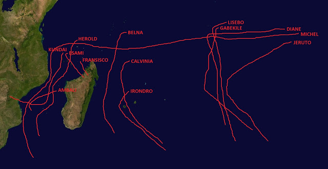
Tropical Cyclone BELNA forms in the vicinity of Seychelles on the 2nd. It peaks with winds of 140 mph on the 7th, and becomes extratropical on the 9th.
Tropical Cyclone CALVINIA forms on the 10th. It peaks with winds of 130 mph on the 12th, and passes very close to Reunion Island as Cat 3 on the next day.
Tropical Cyclone DIANE forms on the 11th. It passes to the north and west of Diego Garcia, and peaks with 150 mph winds on the 15th.
Tropical Cyclone CLAUDIA forms on the 15th. It peaks with winds of 85 mph on the 18th, and becomes extratropical on the 20th.
Tropical Cyclone SARAI forms on the 22nd. It peaks with winds of 80 mph on the 25th, making landfall on Viti Levu with 75 mph winds later the same day.
Tropical Cyclone ESAMI forms on the 24th, and makes landfall with its peak strength of 65 mph in northern Madagascar on the 27th.
February
Tropical Cyclone FRANSISCO forms on the 2nd, and makes landfall with its peak strength of 50 mph in northern Madagascar on the 3rd.
Tropical Cyclone TINO forms on the 10th. It passes through Vanuatu with 40-45 mph winds on the 11th, and peaks with 70 mph winds on the 12th. It makes landfall in New Caledonia on the 13th, and dissipates on the 15th.
Tropical Cyclone GABEKILE forms on the 20th, peaks with 110 mph winds on the 23rd, and becomes extratropical on the 28th.
Tropical Cyclone HEROLD forms on the 21st and peaks with 120 mph winds on the 27th.
Tropical Cyclone DAMIEN forms on the 22nd, peaks with 60 mph winds on the 25th, and becomes extratropical on the 28th.
Tropical Cyclone ESTHER forms on the 27th.
March
HEROLD becomes extratropical on the 3rd.
ESTHER makes landfall in Pilbara on the 1st, with peak winds of 60 mph.
Tropical Cyclone IRONDRO forms on the 5th, peaks with 65 mph winds on the 8th, and becomes extratropical on the 10th.
Tropical Cyclone JERUTO forms on the 9th, peaks with 130 mph winds on the 15th, and becomes extratropical on the 18th.
Tropical Cyclone FERDINAND forms on the 13th, and makes landfall in the Shire of Broome on the 16th with peak winds of 90 mph.
Tropical Cyclone UESI forms on the 16th. It moves to very close to Solomon Islands as a Cat 4 on the 19th and 20th, temporarily weakening while turning slowly to SSE. It peaks with 165 mph winds on the 21st, and becomes extratropical on the 25th.
Tropical Cyclone VICKY forms on the 20th. It peaks with 125 mph winds on the 25th, and becomes extratropical on the 30th.
Tropical Cyclone KUNDAI forms on the 21st. It peaks with 130 mph winds on the 24th, and makes landfall near Beira, Mozambique on the 28th, with winds of 65 mph.
April
Tropical Cyclone LISEBO forms on the 1st. It peaks with 120 mph winds on the 4th, and becomes extratropical on the 9th.
Tropical Cyclone GRETEL forms on the 16th. It peaks with 80 mph winds on the 19th, and dissipates on the 23rd.
Tropical Cyclone MICHEL forms on the 20th. It attains its first peak of 165 mph on the 24th, while making a direct hit on Diego Garcia. After temporary weakening, it attains its biggest peak of 185 mph and 890 mbar on the 27th, while just NE of Agalega. After temporarily weakening again, it attains another peak of 175 mph on the 29th, while passing between Farquhar and Providence atolls.
Tropical Cyclone ONE-V forms on the 28th, while situated 300 miles west of Peruvian coast and 400 miles southeast of Galapagos Islands. It peaks the next day with 50 mph winds, and dissipates on the 30th.
May
MICHEL weakens to below Cat 5 intensity for the last time on the 1st. On the 1st and 2nd, it moves very close to northern Mozambican coast as Cat 4 and Cat 3. On the 5th, it moves very close to southern Mozambican coast as Cat 1. It becomes extratropical on the 6th.
CONCLUSION
The deadliest storm of the season is HIBU, which causes extensive flooding in Papua New Guinea and Solomon Islands, with death toll near 100.
The costliest storm of the season is CALVINIA, which causes near 100 million USD in damages on Reunion Island.
MICHEL has the strongest sustained winds, the lowest pressure, and the highest ACE accumulation ever in the SW Indian Ocean.
ONE-V, as a fully tropical cyclone in South-East Pacific Ocean, is unprecedented.

Comments
Post a Comment