In the year 2100 AD
This is a repost of a Weather Underground blog post.
By: elioe , 11:42 PM GMT on February 24, 2017
This vision assumes, that CO2 levels have risen to 1000 ppm (pretty much "business-as-usual"), no geoengineering has taken place, and no nuclear winter or exceptional volcanic winter has occurred.
This blog entry will be subject to constant editing and additions, whenever my inspiration rages.
General situation:
Sea levels have risen 1.6 meters since 2017.
Azores High has become "Cape Verde High" due to increased coastal upwelling. During winters, there is an additional "Mediterranean High". And during springs, there is a "Eastern U.S. High", which rarely gets intersected by passing troughs.
In other oceanic basins, centers of subtropical highs have also moved towards the equator and towards the east.
In "old conditions", during July-September, Sahara has had a string of surface lows, but the ascending motion at higher altitudes has occurred over Sahel. By 2100, North America has similar pattern: a surface low occurs in Mid-West and Mississippi plains, while a zone of monsoonal rainfall extends from SE Texas through N Florida to coastal Carolinas. This zone makes nearby waters hostile for tropical cyclones, and the occurrence of hurricanes there is as bimodal as the case in N Indian Ocean has previously been. Meanwhile, ITCZ / monsoon trough in Africa has shifted north, especially over Mali/Mauritania, and much of Sahara is no longer a desert.
Arctic Ocean has lost its halocline, its central parts remaining icefree throughout the year. Norwegian branch of thermohaline circulation has steadily grown stronger, while Labrador Sea branch has essentially ceased to exist.
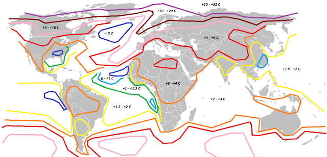
Figures below:
Top: Change in February temperature, compared to 1981-2010.
Bottom: Change in August temperature, compared to 1981-2010.

------------------------------------------------
January
As the new year starts, RSMC Miami issues warnings for Tropical Depression 21-L, which is moving to the southwest, but it dissipates less than a day later, while just to the NE of Barbuda.
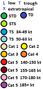
Note: RSMC Miami has long ago abandoned the lists, which begin from A each year. Averages for 2070-2099 are: 21 namable storms, 14 hurricanes, 9 major, 5 Category 5's. Lists are used continuously.
On January 1, Subtropical Storm MIGUEL (01-L) forms 200 mi west of Madeira. Moving slowly to the west at first, later it accelerates to the northeast, and becomes extratropical on January 3, while to the west of Galicia.
On January 10, Subtropical Storm NAFISA (02-L) forms midway between Puerto Rico and Bermuda. Moving little at first, it acquires tropical characteristics, and becomes a hurricane. It accelerates to the NNE, peaks with 80 mph winds, weakens, and becomes extratropical on January 15, while 500 mi NE of Bermuda.
On January 11, RSMC Valparaiso begins issuing advisories on Tropical Depression 02-V, while situated 300 mi NW of Easter Island. It intensifies into Cyclone LUIS, moving to the southeast, and passes just southwest of Easter Island while at peak intensity (80 mph). It later turns to northeast and dissipates on January 19.
On January 25, Subtropical Storm OLE (03-L) forms 850 mi west of Gran Canaria. Moving slowly to SW, it becomes tropical, intensifying into a hurricane, and peaking with 100 mph sustained winds on January 28. It accelerates to the NNE, weakens, and becomes extratropical on February 2, while east of Santa Maria (Azores).
------------------------------------------------
February
On February 6, Super Typhoon MEGI (03-W) makes landfall on Rota with winds of 160 mph.
Throughout late February, cold air in North America moves exceptionally swiftly towards the southwest. Tampico experiences its coldest temperature so far, -5.5 degrees Celsius.
Related to the east-to-west jet stream, which separates warm Arctic air from cold continental air, an extratropical cyclone forms near Novaya Zemlya. It later occludes and moves to southwest, stalling above NW Russia. To the west of this cyclone, a Foehn wind brings Finland a new February heat record, +19.8 degrees Celsius at Muonio.
------------------------------------------------
March
On March 9, Tropical Storm PATTY (04-L) forms 1250 mi NE of Barbuda. It intensifies into a 75 mph hurricane, while moving SSW. It weakens, and dissipates 800 mi E of Barbuda on March 12.
On March 20, Cyclone FERDINAND (09-U) makes landfall near Sunshine Coast, Queensland, with 140 mph winds.
On March 22, Tropical Storm MALIA (01-C) forms from extratropical origins 250 mi SW of Honolulu. Next day, it makes landfall on Oahu with winds of 70 mph, before becoming extratropical.
On March 30, Tropical Storm RAFIQ (05-L) forms near Madeira.
------------------------------------------------
April
On April 2, RAFIQ makes landfall near Essaouira, Morocco, with 60 mph winds.
On April 20, Tropical Depression 02-Q forms 250 mi north of Ascension Island. Moving initially between W and WSW, it intensifies into Tropical Storm KURUPI, and then a hurricane. It turns to the south, and on April 25 it peaks with 140 mph winds, while 100 mi east of Recife. It weakens, and on April 30, it makes landfall on Tristan da Cunha with 80 mph winds. KURUPI has the second lowest pressure in the basin with 933 mbar.
------------------------------------------------
May
On May 1, Tropical Storm SARA (06-L) forms midway between Cape Hatteras and Bermuda. It moves to the southwest, intensifies, and on May 4, it makes landfall at Cocoa Beach, Florida, with winds of 140 mph. Turning to the west, SARA enters Gulf of Mexico with 110 mph winds next day, after going over Tampa. On May 7, it reaches a secondary peak of 130 mph. Dry continental air begins to weaken it, as an approaching trough induces a more northward movement. On May 9, SARA makes its last landfall at Cameron, Louisiana with winds of 90 mph.
First "Cape Verde storm" of the year, Tropical Depression 07-L forms 1000 mi E of Georgetown on May 14. Two days later, it intensifies to Tropical Storm TONY shortly before making landfall near Anna Regina, Guyana.
Tropical Storm UMAYYA (08-L) forms 400 mi SE of Bermuda on May 20. Moving slowly to the SW at first, it later moves to the NE at an increasing speed, and becomes extratropical on May 24.
------------------------------------------------
June
On June 1, Tropical Depression 02-A forms 200 mi W of Mumbai. It moves to the northwest, intensifies into Cyclone KAMALA, and peaks with 190 mph winds. On June 4, it makes landfall near Gwadar, Balochistan, Pakistan, with winds of 175 mph.
On June 2, Tropical Depression 09-L forms, shortly before making landfall near Brunswick, Georgia.
On June 4, Tropical Depression 10-L forms, before intensifying into Tropical Storm VAN, and making landfall at Orinoco Delta the same day. With constant northward shift in movement, VAN comes offshore near Carupano, Venezuela the next day. It strengthens into hurricane on June 7, while between Anguilla and Virgin Islands. On June 10, VAN reaches its peak intensity of 900 mbar and 180 mph, while 620 mi N of San Juan, Puerto Rico. Turning to the southwest and weakening, it makes landfall on San Salvador and Exuma islands on June 12, and on Cayo Romano the next day, while having 110 mph winds. Entering the hot waters of the Caribbean, VAN intensifies before a landfall near Mahahual, Quintana Roo, on June 15, with winds of 140 mph. Later, Tropical Depression VAN (03-E) enters the Pacific and reintensifies.
On June 25, Tropical Storm WILHELMINA (11-L) forms 800 mi WNW of Praia, Cape Verde Islands. It follows a clockwise trajectory, peaking as a hurricane with 100 mph winds. On June 29, it makes landfall near Bir Gandouz, Western Sahara, with winds of 75 mph.
On June 28, Tropical Depression 12-L forms 70 mi S of Charleston, South Carolina. It intensifies into Tropical Storm ADELE, then into a hurricane. On June 30, ADELE makes landfall near Morehead City, North Carolina, with winds of 110 mph.
------------------------------------------------
July
On July 7, Typhoon VAN (11-W) makes landfall on Saipan with winds of 90 mph. After being tropical for 39 days, travelling 17600 kilometers, and becoming Category 5 storm on three occasions, on July 13, Hurricane VAN (03-C) becomes extratropical, while 300 mi SW of Kodiak, Alaska.
After minimal Hurricane BERTIL (13-L) and Tropical Storm CORINNA (14-L), Tropical Storm DORIAN (15-L) forms near Roatan on July 10, before making landfall near Dangriga, Belize. The weakened tropical depression enters the Bay of Campeche, before rapidly intensifying. On July 13, DORIAN reaches peak intensity of 160 mph, while 110 mi NE of Veracruz. Moving to the north, it weakens rapidly while nearing the U.S. Gulf Coast. On July 16, DORIAN makes landfall near Galveston, Texas, with 35 mph winds.
On July 13, Tropical Depression 16-L forms 700 mi E of Barbuda, before intensifying into Tropical Storm ELLA (16-L). On July 19, it reaches winds of 160 mph, while 80 mi W of Bermuda. On July 23, ELLA becomes extratropical, while 200 mi N of Corvo, Azores.
Tropical Storm FAWAZ (17-L) does not affect land.
On July 24, Dallas, Texas, reaches 52.8 degrees Celsius, a new record.
------------------------------------------------
August
After hurricanes GABRIELLE (18-L) and HERMANN (19-L), as well as Tropical Storm IRINA (20-L), comes Tropical Storm JERRY (21-L). It intensifies into a major hurricane of 120 mph winds east of the Lesser Antilles, before weakening and making landfall on Grenada with winds of 40 mph.
On August 15, Tropical Depression 22-L forms near Bimini. Later that day, it becomes Tropical Storm KARIMA, before making landfall near Hollywood, Florida. It weakens and moves slowly to the north, to be absorbed to the N American Monsoon Trough. It dissipates on August 19, while near Jacksonville, Florida. Biggest rainfall total is at Sebring, Florida: 55 inches. Miami receives 42 inches and Orlando 44 inches.
Hurricane LORENZO (23-L) with its 135 mph winds does not affect land.
On August 22, Tropical Depression 24-L forms 150 mi N of San Juan, Puerto Rico, before intensifying into Tropical Storm MUNA. It moves just north of the Turks and Caicos, and just to the east of the Bahamas. Later, it turns to the north, and then to the east. On August 28, MUNA peaks with 190 mph winds. The next day, it passes 25 mi S of Bermuda. Nearing the East Atlantic, MUNA begins to turn to the north. Meanwhile, general slow weakening is accompanied by fluctuations.
On August 23, Tropical Storm NESTOR (25-L) forms 600 mi S of St. John's, Newfoundland. Moving to the NNE, it becomes extratropical two days later, while 500 mi E of St. John's.
------------------------------------------------
September
Hurricane MUNA (24-L) passes between Sao Miguel and Santa Maria in the Azores on September 5, while sustained winds are at 125 mph. On September 7, it makes landfall at Fisterra, A Coruna, Spain, with winds of 80 mph. The next day, it makes landfall near La Rochelle, France, with winds of 50 mph.
After Cat 5 Hurricane OLGA (26-L) spins harmlessly through the central Atlantic, and Tropical Storm PIERRE (27-L) briefly annoys the coasts of Mexico and S Texas, Tropical Depression 28-L forms on September 10, and strengthens into Tropical Storm RIHANNA two days later, while near Grand Cayman. Moving slowly to SW, then to NW, RIHANNA rapidly intensifies into a Category 5 storm, peaking on September 14 with 869 mbar pressure and 200 mph winds. On September 16, it makes landfall near Tulum, Quintana Roo, with winds of 165 mph. Entering the Gulf of Mexico and steadily weakening but becoming larger, RIHANNA makes landfall near Fish Creek, Florida on September 19 with winds of 50 mph and a pressure of 970 mbar. At that time, gale force winds are being felt all the way from Pensacola to Sarasota.
After Subtropical Storm SAID (29-L) had had a brief life to the W of Ireland, Tropical Depression 30-L forms 900 mi SW of Ponta Delgada, Azores. Moving to the north, then to the northeast, 30-L intensifies into Tropical Storm TAMARA, and finally to a major hurricane with 115 mph winds. At that intensity, it makes landfall on Sao Miguel in the Azores on September 20. On September 23, TAMARA makes landfall near Portsmouth, England, with winds of 80 mph. Later emerging into the North Sea, advisories are being issued by RSMC Hamburg on TAMARA (01-N). On September 24, it makes landfall near Esbjerg, Denmark, with winds of 50 mph. The next day, TAMARA makes landfall near Kungsbacka, Sweden, with 35 mph winds, and then dissipates.
Hurricane UDAY (31-L) makes landfall near Mobile, Alabama, on September 30 with winds of 75 mph.
------------------------------------------------
October
On October 1, Polar Low 03-X forms 50 mi S of Salm Island, Franz Josef Land. Moving to the SW, and peaking with 80 mph winds, it makes landfall near Teriberka, Murmansk Oblast, Russia on October 5 with winds of 70 mph.
On October 5, Hurricane VANESSA (32-L) makes landfall at Matagorda, Texas, with its peak winds of 120 mph.
Note: By the year 2100 AD, increased precipitation minus evaporation in western parts of Sahara has caused permanent lakes to emerge in many places.
On October 12, a tropical depression forms over the Meqerghane Lake in SW Algeria. Moving to the northeast, it eventually enters Jerid Lake. It develops higher winds, and when entering the Mediterranean Sea on October 16, RSMC Athens begins issuing advisories on Tropical Storm ALEXIOS (01-M). It peaks with 120 mph winds, before making landfall on Zakynthos Island and near Kyllini on the Peloponnesos on October 19 with winds of 80 mph.
Tropical Depression 33-L makes landfall near Savannah, Georgia on October 19.
On October 20, Hurricane ELIDA (10-E) makes landfall near Cabo San Lucas, Baja California Sur, with winds of 155 mph. On October 22, it makes landfall west of Puerto Penasco, Sonora, with 100 mph winds. The next day it crosses Mexico-U.S. border near Yuma as a tropical storm. Its remnants then stall in the vicinity of Salton Sea.
On October 31, Tropical Depression 34-L forms halfway between Grand Cayman and Cabo Gracias a Dios.
------------------------------------------------
November
On November 1, TD 34-L intensifies into Tropical Storm WENDY. Explosively deepening further, it reaches a pressure of 870 mbar and winds of 200 mph, while 80 mi SW of Grand Cayman on November 2. The next day, WENDY has an eyewall replacement cycle. In the beginning of the cycle, the hurricane is 50 mi W of Grand Cayman. The eyewall replacement gets completed, and the intensification resumes with a larger size of wind field and eyewall radius. Early on November 4, WENDY makes landfall at Playa Giron, Cuba, with winds of 200 mph and a central pressure of 830 mbar. A day later, WENDY makes landfall on Great Abaco, with winds of 165 mph. On November 9, WENDY makes landfall near Portmagee, Ireland, with winds of 75 mph, and becomes extratropical shortly afterwards. The 830 mbar minimum pressure is a new record, beating 832 mbar set in year 2095 AD. But the maximum sustained winds do not break records, which are being still held by the 2095 storm (250 mph).
On November 3, Tropical Depression 35-L forms 600 mi ENE of Amapa, Brazil. It strengthens into Tropical Storm ARNOLD, and further into a hurricane, before making landfall near Mafeking, Trinidad on November 7 with winds of 110 mph. It further intensifies into a Cat 5 with 160 mph winds, before making landfall near Ponce, Puerto Rico on November 10 with winds of 155 mph. Continuing to the NNE, ARNOLD becomes extratropical on November 14.
Note: Southeastern parts of California have exhibited huge positive trends in precipitation, especially in the latter part of 21st Century.
On November 4, due to the huge rainfall from ELIDA (10-E) and its remnants, for the first time, waters from Salton Sea flow to Colorado River.
Tropical Storm BEIRA (36-L) makes landfall in Panama on November 9. After that, tropical storms CRISTOBAL (37-L) and DINA (38-L) swirl in the Western Atlantic without affecting land.
Tropical Depression 39-L forms 900 mi E of Cayenne, French Guiana, and intensifies to Tropical Storm EDMUND. It intensifies into a 175 mph hurricane, before making landfall near Kourou, French Guiana at that intensity on November 29.
------------------------------------------------
December
On December 1, Tropical Storm FANNY (40-L) forms 150 mi NE of Cockburn Town, Turks and Caicos. Moving originally to the SSW, it passes Turks and Caicos to the east, then to the south, and makes landfall on Little Inagua with winds of 120 mph. On December 5, the now NNE-moving hurricane reaches a peak of 140 mph. On December 7, FANNY becomes extratropical.
On December 20, Tropical Storm GONZALO (41-L) forms in the Central Atlantic, never affecting land.
On December 21, Tropical Storm HENNA (42-L) forms 100 mi NE of Cabo Gracias a Dios. Moving slowly to the northwest, it peaks as a 165 mph hurricane, before making landfall near Cancun, Quintana Roo, on December 24 with winds of 150 mph. It becomes extratropical over the central Gulf of Mexico next day, the remnants bringing hurricane-force winds to NW Florida.
On December 22, RSMC Lagos begins issuing advisories on Tropical Depression 01-G, located 50 mi W of Bata, Equatorial Guinea. Moving to the NW and being named BUKOLA, it makes landfall at Ouidah, Benin on December 25 with winds of 80 mph.
On December 24, RSMC Nadi begins issuing advisories on Tropical Depression 04-F, situated 1000 mi E of Hiva Oa, French Polynesia. It intensifies into Cyclone NIKO, while moving first slowly to SW, later accelerating towards SE, and crossing into AOR of RSMC Valparaiso. On December 29, NIKO (01-V) reaches peak intensity of 160 mph and 925 mbar, while 330 mi NNW of Easter Island. This makes it the strongest system and first Category 5 system to exist in the Southeast Pacific basin.
------------------------------------------------
Conclusion
The 2100 Atlantic hurricane season broke records. With 40 named storms, it surpassed the 2097 season, which had 36 storms. Before that, record was held by 2045 season with 33 storms. HENNA was the latest Category 5 to occur within an Atlantic hurricane season. The 200 mph landfall of WENDY is a new national record for Cuba.
By: elioe , 11:42 PM GMT on February 24, 2017
This vision assumes, that CO2 levels have risen to 1000 ppm (pretty much "business-as-usual"), no geoengineering has taken place, and no nuclear winter or exceptional volcanic winter has occurred.
This blog entry will be subject to constant editing and additions, whenever my inspiration rages.
General situation:
Sea levels have risen 1.6 meters since 2017.
Azores High has become "Cape Verde High" due to increased coastal upwelling. During winters, there is an additional "Mediterranean High". And during springs, there is a "Eastern U.S. High", which rarely gets intersected by passing troughs.
In other oceanic basins, centers of subtropical highs have also moved towards the equator and towards the east.
In "old conditions", during July-September, Sahara has had a string of surface lows, but the ascending motion at higher altitudes has occurred over Sahel. By 2100, North America has similar pattern: a surface low occurs in Mid-West and Mississippi plains, while a zone of monsoonal rainfall extends from SE Texas through N Florida to coastal Carolinas. This zone makes nearby waters hostile for tropical cyclones, and the occurrence of hurricanes there is as bimodal as the case in N Indian Ocean has previously been. Meanwhile, ITCZ / monsoon trough in Africa has shifted north, especially over Mali/Mauritania, and much of Sahara is no longer a desert.
Arctic Ocean has lost its halocline, its central parts remaining icefree throughout the year. Norwegian branch of thermohaline circulation has steadily grown stronger, while Labrador Sea branch has essentially ceased to exist.
Figures below:
Top: Change in February temperature, compared to 1981-2010.
Bottom: Change in August temperature, compared to 1981-2010.


------------------------------------------------
January
As the new year starts, RSMC Miami issues warnings for Tropical Depression 21-L, which is moving to the southwest, but it dissipates less than a day later, while just to the NE of Barbuda.
Note: RSMC Miami has long ago abandoned the lists, which begin from A each year. Averages for 2070-2099 are: 21 namable storms, 14 hurricanes, 9 major, 5 Category 5's. Lists are used continuously.
On January 1, Subtropical Storm MIGUEL (01-L) forms 200 mi west of Madeira. Moving slowly to the west at first, later it accelerates to the northeast, and becomes extratropical on January 3, while to the west of Galicia.
On January 10, Subtropical Storm NAFISA (02-L) forms midway between Puerto Rico and Bermuda. Moving little at first, it acquires tropical characteristics, and becomes a hurricane. It accelerates to the NNE, peaks with 80 mph winds, weakens, and becomes extratropical on January 15, while 500 mi NE of Bermuda.
On January 11, RSMC Valparaiso begins issuing advisories on Tropical Depression 02-V, while situated 300 mi NW of Easter Island. It intensifies into Cyclone LUIS, moving to the southeast, and passes just southwest of Easter Island while at peak intensity (80 mph). It later turns to northeast and dissipates on January 19.
On January 25, Subtropical Storm OLE (03-L) forms 850 mi west of Gran Canaria. Moving slowly to SW, it becomes tropical, intensifying into a hurricane, and peaking with 100 mph sustained winds on January 28. It accelerates to the NNE, weakens, and becomes extratropical on February 2, while east of Santa Maria (Azores).
------------------------------------------------
February
On February 6, Super Typhoon MEGI (03-W) makes landfall on Rota with winds of 160 mph.
Throughout late February, cold air in North America moves exceptionally swiftly towards the southwest. Tampico experiences its coldest temperature so far, -5.5 degrees Celsius.
Related to the east-to-west jet stream, which separates warm Arctic air from cold continental air, an extratropical cyclone forms near Novaya Zemlya. It later occludes and moves to southwest, stalling above NW Russia. To the west of this cyclone, a Foehn wind brings Finland a new February heat record, +19.8 degrees Celsius at Muonio.
------------------------------------------------
March
On March 9, Tropical Storm PATTY (04-L) forms 1250 mi NE of Barbuda. It intensifies into a 75 mph hurricane, while moving SSW. It weakens, and dissipates 800 mi E of Barbuda on March 12.
On March 20, Cyclone FERDINAND (09-U) makes landfall near Sunshine Coast, Queensland, with 140 mph winds.
On March 22, Tropical Storm MALIA (01-C) forms from extratropical origins 250 mi SW of Honolulu. Next day, it makes landfall on Oahu with winds of 70 mph, before becoming extratropical.
On March 30, Tropical Storm RAFIQ (05-L) forms near Madeira.
------------------------------------------------
April
On April 2, RAFIQ makes landfall near Essaouira, Morocco, with 60 mph winds.
On April 20, Tropical Depression 02-Q forms 250 mi north of Ascension Island. Moving initially between W and WSW, it intensifies into Tropical Storm KURUPI, and then a hurricane. It turns to the south, and on April 25 it peaks with 140 mph winds, while 100 mi east of Recife. It weakens, and on April 30, it makes landfall on Tristan da Cunha with 80 mph winds. KURUPI has the second lowest pressure in the basin with 933 mbar.
------------------------------------------------
May
On May 1, Tropical Storm SARA (06-L) forms midway between Cape Hatteras and Bermuda. It moves to the southwest, intensifies, and on May 4, it makes landfall at Cocoa Beach, Florida, with winds of 140 mph. Turning to the west, SARA enters Gulf of Mexico with 110 mph winds next day, after going over Tampa. On May 7, it reaches a secondary peak of 130 mph. Dry continental air begins to weaken it, as an approaching trough induces a more northward movement. On May 9, SARA makes its last landfall at Cameron, Louisiana with winds of 90 mph.
First "Cape Verde storm" of the year, Tropical Depression 07-L forms 1000 mi E of Georgetown on May 14. Two days later, it intensifies to Tropical Storm TONY shortly before making landfall near Anna Regina, Guyana.
Tropical Storm UMAYYA (08-L) forms 400 mi SE of Bermuda on May 20. Moving slowly to the SW at first, it later moves to the NE at an increasing speed, and becomes extratropical on May 24.
------------------------------------------------
June
On June 1, Tropical Depression 02-A forms 200 mi W of Mumbai. It moves to the northwest, intensifies into Cyclone KAMALA, and peaks with 190 mph winds. On June 4, it makes landfall near Gwadar, Balochistan, Pakistan, with winds of 175 mph.
On June 2, Tropical Depression 09-L forms, shortly before making landfall near Brunswick, Georgia.
On June 4, Tropical Depression 10-L forms, before intensifying into Tropical Storm VAN, and making landfall at Orinoco Delta the same day. With constant northward shift in movement, VAN comes offshore near Carupano, Venezuela the next day. It strengthens into hurricane on June 7, while between Anguilla and Virgin Islands. On June 10, VAN reaches its peak intensity of 900 mbar and 180 mph, while 620 mi N of San Juan, Puerto Rico. Turning to the southwest and weakening, it makes landfall on San Salvador and Exuma islands on June 12, and on Cayo Romano the next day, while having 110 mph winds. Entering the hot waters of the Caribbean, VAN intensifies before a landfall near Mahahual, Quintana Roo, on June 15, with winds of 140 mph. Later, Tropical Depression VAN (03-E) enters the Pacific and reintensifies.
On June 25, Tropical Storm WILHELMINA (11-L) forms 800 mi WNW of Praia, Cape Verde Islands. It follows a clockwise trajectory, peaking as a hurricane with 100 mph winds. On June 29, it makes landfall near Bir Gandouz, Western Sahara, with winds of 75 mph.
On June 28, Tropical Depression 12-L forms 70 mi S of Charleston, South Carolina. It intensifies into Tropical Storm ADELE, then into a hurricane. On June 30, ADELE makes landfall near Morehead City, North Carolina, with winds of 110 mph.
------------------------------------------------
July
On July 7, Typhoon VAN (11-W) makes landfall on Saipan with winds of 90 mph. After being tropical for 39 days, travelling 17600 kilometers, and becoming Category 5 storm on three occasions, on July 13, Hurricane VAN (03-C) becomes extratropical, while 300 mi SW of Kodiak, Alaska.
After minimal Hurricane BERTIL (13-L) and Tropical Storm CORINNA (14-L), Tropical Storm DORIAN (15-L) forms near Roatan on July 10, before making landfall near Dangriga, Belize. The weakened tropical depression enters the Bay of Campeche, before rapidly intensifying. On July 13, DORIAN reaches peak intensity of 160 mph, while 110 mi NE of Veracruz. Moving to the north, it weakens rapidly while nearing the U.S. Gulf Coast. On July 16, DORIAN makes landfall near Galveston, Texas, with 35 mph winds.
On July 13, Tropical Depression 16-L forms 700 mi E of Barbuda, before intensifying into Tropical Storm ELLA (16-L). On July 19, it reaches winds of 160 mph, while 80 mi W of Bermuda. On July 23, ELLA becomes extratropical, while 200 mi N of Corvo, Azores.
Tropical Storm FAWAZ (17-L) does not affect land.
On July 24, Dallas, Texas, reaches 52.8 degrees Celsius, a new record.
------------------------------------------------
August
After hurricanes GABRIELLE (18-L) and HERMANN (19-L), as well as Tropical Storm IRINA (20-L), comes Tropical Storm JERRY (21-L). It intensifies into a major hurricane of 120 mph winds east of the Lesser Antilles, before weakening and making landfall on Grenada with winds of 40 mph.
On August 15, Tropical Depression 22-L forms near Bimini. Later that day, it becomes Tropical Storm KARIMA, before making landfall near Hollywood, Florida. It weakens and moves slowly to the north, to be absorbed to the N American Monsoon Trough. It dissipates on August 19, while near Jacksonville, Florida. Biggest rainfall total is at Sebring, Florida: 55 inches. Miami receives 42 inches and Orlando 44 inches.
Hurricane LORENZO (23-L) with its 135 mph winds does not affect land.
On August 22, Tropical Depression 24-L forms 150 mi N of San Juan, Puerto Rico, before intensifying into Tropical Storm MUNA. It moves just north of the Turks and Caicos, and just to the east of the Bahamas. Later, it turns to the north, and then to the east. On August 28, MUNA peaks with 190 mph winds. The next day, it passes 25 mi S of Bermuda. Nearing the East Atlantic, MUNA begins to turn to the north. Meanwhile, general slow weakening is accompanied by fluctuations.
On August 23, Tropical Storm NESTOR (25-L) forms 600 mi S of St. John's, Newfoundland. Moving to the NNE, it becomes extratropical two days later, while 500 mi E of St. John's.
------------------------------------------------
September
Hurricane MUNA (24-L) passes between Sao Miguel and Santa Maria in the Azores on September 5, while sustained winds are at 125 mph. On September 7, it makes landfall at Fisterra, A Coruna, Spain, with winds of 80 mph. The next day, it makes landfall near La Rochelle, France, with winds of 50 mph.
After Cat 5 Hurricane OLGA (26-L) spins harmlessly through the central Atlantic, and Tropical Storm PIERRE (27-L) briefly annoys the coasts of Mexico and S Texas, Tropical Depression 28-L forms on September 10, and strengthens into Tropical Storm RIHANNA two days later, while near Grand Cayman. Moving slowly to SW, then to NW, RIHANNA rapidly intensifies into a Category 5 storm, peaking on September 14 with 869 mbar pressure and 200 mph winds. On September 16, it makes landfall near Tulum, Quintana Roo, with winds of 165 mph. Entering the Gulf of Mexico and steadily weakening but becoming larger, RIHANNA makes landfall near Fish Creek, Florida on September 19 with winds of 50 mph and a pressure of 970 mbar. At that time, gale force winds are being felt all the way from Pensacola to Sarasota.
After Subtropical Storm SAID (29-L) had had a brief life to the W of Ireland, Tropical Depression 30-L forms 900 mi SW of Ponta Delgada, Azores. Moving to the north, then to the northeast, 30-L intensifies into Tropical Storm TAMARA, and finally to a major hurricane with 115 mph winds. At that intensity, it makes landfall on Sao Miguel in the Azores on September 20. On September 23, TAMARA makes landfall near Portsmouth, England, with winds of 80 mph. Later emerging into the North Sea, advisories are being issued by RSMC Hamburg on TAMARA (01-N). On September 24, it makes landfall near Esbjerg, Denmark, with winds of 50 mph. The next day, TAMARA makes landfall near Kungsbacka, Sweden, with 35 mph winds, and then dissipates.
Hurricane UDAY (31-L) makes landfall near Mobile, Alabama, on September 30 with winds of 75 mph.
------------------------------------------------
October
On October 1, Polar Low 03-X forms 50 mi S of Salm Island, Franz Josef Land. Moving to the SW, and peaking with 80 mph winds, it makes landfall near Teriberka, Murmansk Oblast, Russia on October 5 with winds of 70 mph.
On October 5, Hurricane VANESSA (32-L) makes landfall at Matagorda, Texas, with its peak winds of 120 mph.
Note: By the year 2100 AD, increased precipitation minus evaporation in western parts of Sahara has caused permanent lakes to emerge in many places.
On October 12, a tropical depression forms over the Meqerghane Lake in SW Algeria. Moving to the northeast, it eventually enters Jerid Lake. It develops higher winds, and when entering the Mediterranean Sea on October 16, RSMC Athens begins issuing advisories on Tropical Storm ALEXIOS (01-M). It peaks with 120 mph winds, before making landfall on Zakynthos Island and near Kyllini on the Peloponnesos on October 19 with winds of 80 mph.
Tropical Depression 33-L makes landfall near Savannah, Georgia on October 19.
On October 20, Hurricane ELIDA (10-E) makes landfall near Cabo San Lucas, Baja California Sur, with winds of 155 mph. On October 22, it makes landfall west of Puerto Penasco, Sonora, with 100 mph winds. The next day it crosses Mexico-U.S. border near Yuma as a tropical storm. Its remnants then stall in the vicinity of Salton Sea.
On October 31, Tropical Depression 34-L forms halfway between Grand Cayman and Cabo Gracias a Dios.
------------------------------------------------
November
On November 1, TD 34-L intensifies into Tropical Storm WENDY. Explosively deepening further, it reaches a pressure of 870 mbar and winds of 200 mph, while 80 mi SW of Grand Cayman on November 2. The next day, WENDY has an eyewall replacement cycle. In the beginning of the cycle, the hurricane is 50 mi W of Grand Cayman. The eyewall replacement gets completed, and the intensification resumes with a larger size of wind field and eyewall radius. Early on November 4, WENDY makes landfall at Playa Giron, Cuba, with winds of 200 mph and a central pressure of 830 mbar. A day later, WENDY makes landfall on Great Abaco, with winds of 165 mph. On November 9, WENDY makes landfall near Portmagee, Ireland, with winds of 75 mph, and becomes extratropical shortly afterwards. The 830 mbar minimum pressure is a new record, beating 832 mbar set in year 2095 AD. But the maximum sustained winds do not break records, which are being still held by the 2095 storm (250 mph).
On November 3, Tropical Depression 35-L forms 600 mi ENE of Amapa, Brazil. It strengthens into Tropical Storm ARNOLD, and further into a hurricane, before making landfall near Mafeking, Trinidad on November 7 with winds of 110 mph. It further intensifies into a Cat 5 with 160 mph winds, before making landfall near Ponce, Puerto Rico on November 10 with winds of 155 mph. Continuing to the NNE, ARNOLD becomes extratropical on November 14.
Note: Southeastern parts of California have exhibited huge positive trends in precipitation, especially in the latter part of 21st Century.
On November 4, due to the huge rainfall from ELIDA (10-E) and its remnants, for the first time, waters from Salton Sea flow to Colorado River.
Tropical Storm BEIRA (36-L) makes landfall in Panama on November 9. After that, tropical storms CRISTOBAL (37-L) and DINA (38-L) swirl in the Western Atlantic without affecting land.
Tropical Depression 39-L forms 900 mi E of Cayenne, French Guiana, and intensifies to Tropical Storm EDMUND. It intensifies into a 175 mph hurricane, before making landfall near Kourou, French Guiana at that intensity on November 29.
------------------------------------------------
December
On December 1, Tropical Storm FANNY (40-L) forms 150 mi NE of Cockburn Town, Turks and Caicos. Moving originally to the SSW, it passes Turks and Caicos to the east, then to the south, and makes landfall on Little Inagua with winds of 120 mph. On December 5, the now NNE-moving hurricane reaches a peak of 140 mph. On December 7, FANNY becomes extratropical.
On December 20, Tropical Storm GONZALO (41-L) forms in the Central Atlantic, never affecting land.
On December 21, Tropical Storm HENNA (42-L) forms 100 mi NE of Cabo Gracias a Dios. Moving slowly to the northwest, it peaks as a 165 mph hurricane, before making landfall near Cancun, Quintana Roo, on December 24 with winds of 150 mph. It becomes extratropical over the central Gulf of Mexico next day, the remnants bringing hurricane-force winds to NW Florida.
On December 22, RSMC Lagos begins issuing advisories on Tropical Depression 01-G, located 50 mi W of Bata, Equatorial Guinea. Moving to the NW and being named BUKOLA, it makes landfall at Ouidah, Benin on December 25 with winds of 80 mph.
On December 24, RSMC Nadi begins issuing advisories on Tropical Depression 04-F, situated 1000 mi E of Hiva Oa, French Polynesia. It intensifies into Cyclone NIKO, while moving first slowly to SW, later accelerating towards SE, and crossing into AOR of RSMC Valparaiso. On December 29, NIKO (01-V) reaches peak intensity of 160 mph and 925 mbar, while 330 mi NNW of Easter Island. This makes it the strongest system and first Category 5 system to exist in the Southeast Pacific basin.
------------------------------------------------
Conclusion
The 2100 Atlantic hurricane season broke records. With 40 named storms, it surpassed the 2097 season, which had 36 storms. Before that, record was held by 2045 season with 33 storms. HENNA was the latest Category 5 to occur within an Atlantic hurricane season. The 200 mph landfall of WENDY is a new national record for Cuba.
Comments
Post a Comment